
Risk: A Discontinued Hobby
Risk is one of those board games that commands respect: once you start, you never know when you’ll finish; you risk losing friendships along the way, and when you lose, you invariably point to bad luck as the culprit.
Risk is a complicated game, with long turns where strategy, diplomacy, and luck play crucial roles. Much like Monopoly, hours of gameplay chain together, turning into a sort of marathon that requires patience and dedication.
I discovered Risk in my teens. I used to frequent the Dracs d’Eivissa association with my friends. Christian, Sergio, Leandro, Sofía, Giulia, and I would meet with the regulars of the association to play their wide selection of board games. Among them, a Game of Thrones version of Risk stood out—the one we turned to whenever we wanted to spend hours together demonstrating our ambition and strategy. Sergio was truly ambitious; he conquered territories relentlessly, and his army seemed inexhaustible, so he often became the primary target that we all united against.
Those hours of gaming created indelible memories, but over time, life took us down different paths, preventing us from meeting as frequently. Even so, the remnant of that passion for Risk remained, waiting for the opportunity to resurface.
The Digital World
Moving a board game to a digital format opens up new possibilities. The automation of rules and game management allows players to focus on strategy and interaction without worrying about logistical aspects. Risk is one of those games that benefits enormously from digitalization, as the rules can be complex and tracking turns can be tedious.
The company that owns the brand has launched digital versions of Risk for various platforms. It became a very popular game during the 2020 pandemic when outdoor access was a scarce resource. Major streamers like Ibai Llanos took the opportunity to live-stream Risk matches, attracting a large audience and revitalizing interest in the game.
Aside from the official version, the fan community has developed multiple versions under different names, such as Domination. The great advantage of these versions is that they allow for the creation of custom maps, adapting the game to whatever themes and playstyles the user desires. In Domination, for example, you can import any image as a map and, from there, define territories, connections, and other configurations.

Domination: a free digital version of Risk.
How to Create a Risk Map
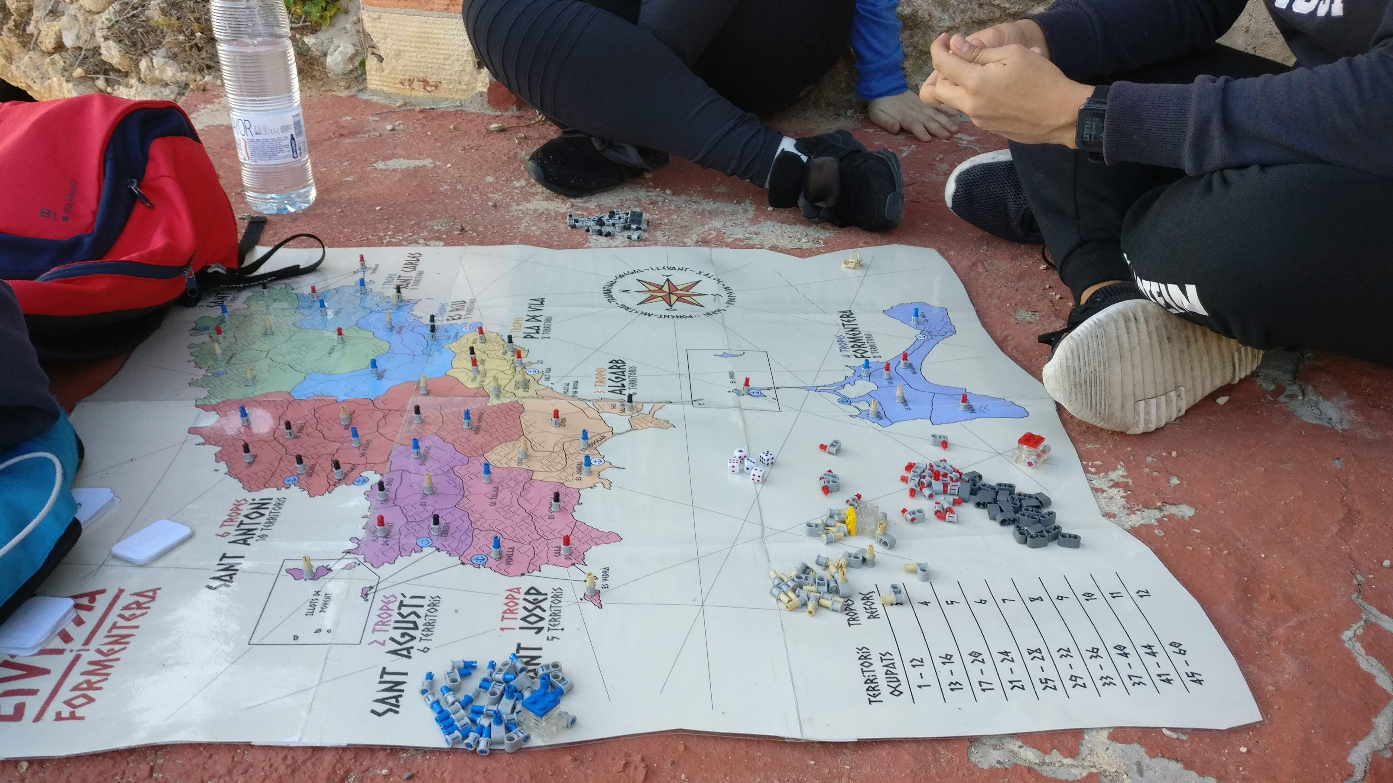
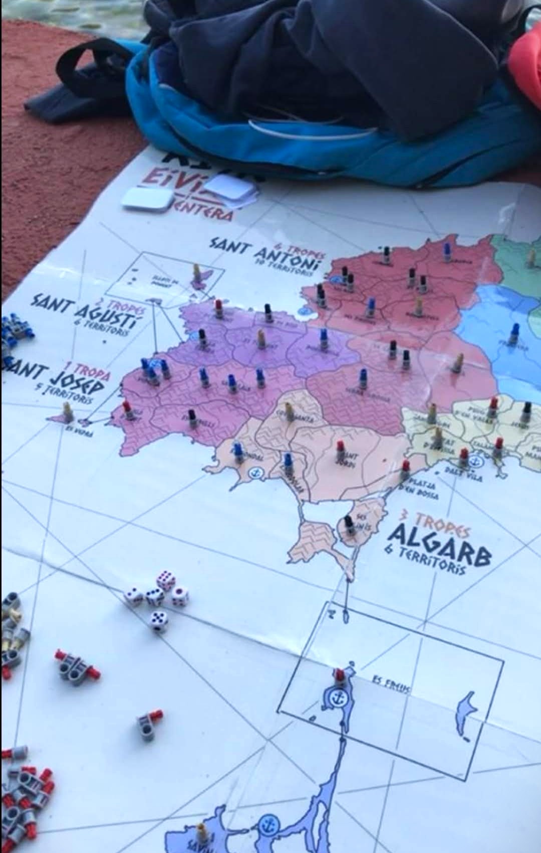
Creating custom maps is, for me, a creative and entertaining process that allows me to combine my hobbies for graphic design, geography, and strategy. Below, I explain the steps I usually follow to create a map and how I applied them to the creation of the map Risc: Eivissa i Formentera, based on the Pityusic Islands.
1. Theme
The theme, although it might not seem like the most important part, is the differentiating element. It is the story that hooks the players and provides them with context and meaning. Therefore, it’s worth finding an original theme and developing a narrative that captivates the players. The theme holds together the visual design of the map, the names of the territories, and even the cards and special rules.
In my case, I used the geography, history, and culture of the Pityusic Islands (Ibiza and Formentera) as a theme. The map reflects the historical territorial division of the islands, inspired by the ancient division into quartons and véndes. The cards, for their part, include references to popular culture, traditions, and local expressions.
Below, I’ll explain a bit more about this historical division.
And now, a bit of history
During Muslim rule, the island of Ibiza was divided into five districts: Algarb, Portumany, Benizamid, Xarc, and Alhueth. With the Catalan conquest of 1235, this division was reconfigured into four parts called Quartons (Portmany, Balansat, del Rei, and de Ses Salines), which mean “quarters” in Catalan and were distributed based on the feudal lords’ contribution to the military enterprise. Thus, two quartons went to Guillem de Montgrí, Archbishop of Tarragona, one quartó to Infante Pedro of Portugal, and the other to Nuño Sánchez, Count of Roussillon. Upon Nuño Sánchez’s death, his feudal rights passed to James I, which is why the eastern quartó is known as del Rei (the King’s).
To these four quartons was added the town of Ibiza (Vila), which formed a separate entity but was also divided into four equal parts. The usufruct of the salt flats (salinas) was also divided, since salt was considered a strategic resource at the time. Regarding Formentera, there is evidence that it was also divided into quartons, but that division was not maintained due to its depopulation over long periods of time.
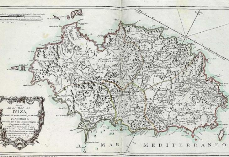
Old map showing the division into quartons and the plan of Vila.
The centuries following the conquest were marked by piracy and Barbary attacks, which led to the construction of numerous defense towers around the island. The inhabitants of each quartó divided themselves territorially to take responsibility for defense. Thus, watch shifts and maintenance of the fortifications were established based on the territory they belonged to. These territories took their names from these shifts, being called véndes—a term that comes from the Latin vices, meaning “alternation” or “turn.”
The division into quartons was maintained until the application of the Nueva Planta Decrees in 1715, which abolished feudal rights and traditional territorial divisions, establishing a single City Council for the whole island.
During the 18th century, Enlightenment ideas promoted reforms to prevent the economic and social backwardness of the islands. Among other actors, the Catholic Church promoted the construction of new parishes to reduce population dispersal, which was identified as a possible cause of the general delay. The population settled near the temples with limited success, forming new villages that took the name of the parish’s patron saint. In 1785, Bishop Manuel Abat y Lasierra created the parish division of the island by grouping several véndes under the jurisdiction of the same temple. Later, in the 19th century, the current municipalities were established by grouping several parishes, once again resembling the historical division into quartons.
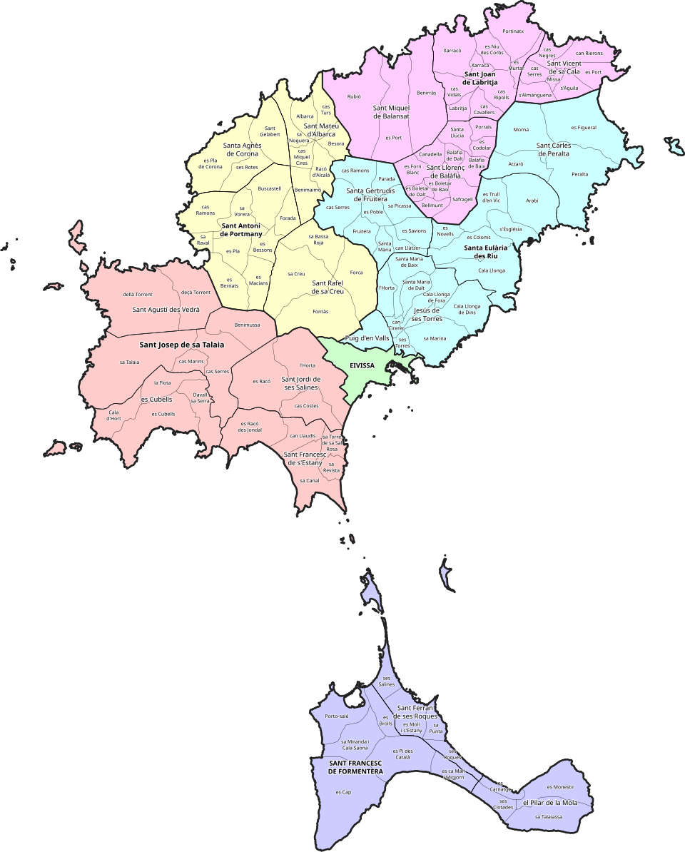
Possibly the most detailed source on the territorial division of the Pityusic Islands comes from the study by historian Joan Marí Cardona (1925-2002). The map reflects the traditional division of the islands into municipalities, parishes, and véndes.
2. Define Territories and Continents
The dynamics of Risk revolve around the concept of territories and continents. A territory is a basic unit of the map that players can conquer and defend, while a continent is a group of territories clustered geographically, whose total control grants additional bonuses to the players who possess them.
In general, more territories imply more playtime, which can be a challenge for players who don’t want eternal matches. A number of territories between 30 and 50 is a good balance. As for continents, it is advisable to have between 4 and 6, each with a balanced number of territories. In the classic map, there are six continents: North America (9), South America (4), Europe (7), Africa (6), Asia (12), and Oceania (4).
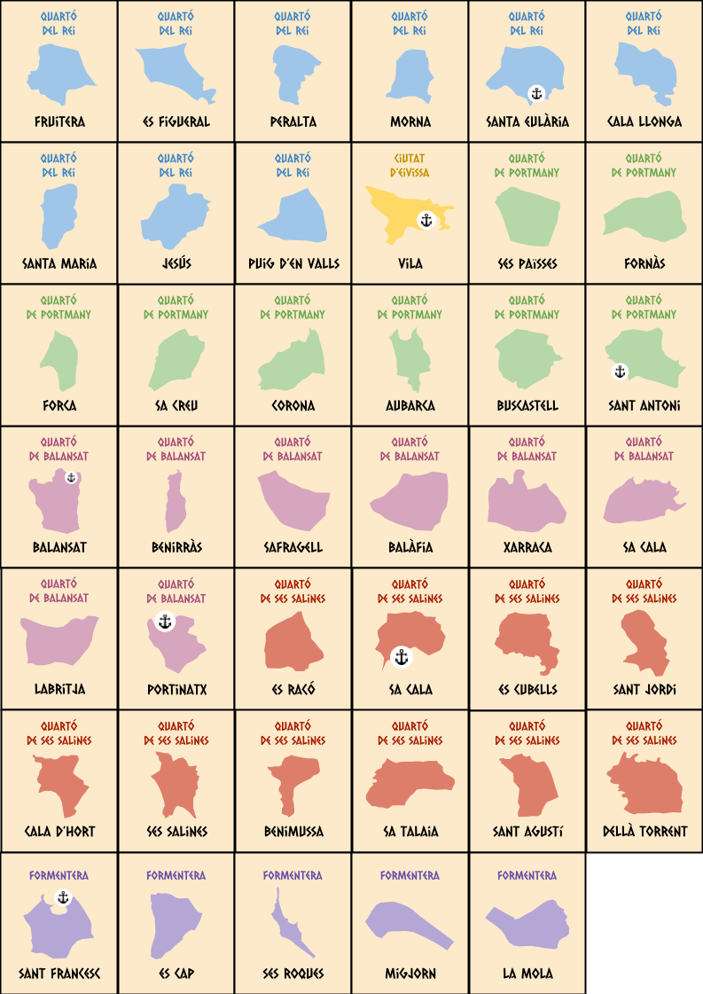
When designing the map of the Pityusic Islands, I decided to create a total of 41 territories divided into six continents: the 4 quartons of Ibiza, the city of Ibiza, and the island of Formentera. Since the number of véndes is too high for a Risk map, I decided to group several véndes to form the territories, while maintaining the essence of the historical division.
3. Connect the Territories
Once the territories are defined, it is important to establish the connections between them. These connections determine where troops can move and attack other players. It is important to balance connections to prevent certain territories from being too easy or too difficult to defend. A good rule of thumb is to have a minimum of 2 and a maximum of 6 connections per territory.
In classic Risk, connections typically represent land borders, but there are also maritime connections that allow movement between territories separated by water. When creating a custom map, you can decide what type of connections to include and how they affect the game’s strategy.
To carry out this task, it is useful to create a preliminary sketch of the map representing the territories as nodes and the connections as lines between them. This will allow you to visualize the network of connections and make adjustments as necessary to achieve a proper balance. If you decide to make the map in Domination, you will see that this step is mandatory, as the program will ask you to define the connections between territories.
In my case, when designing the map of the Pityusic Islands, I took advantage of two key geographical features:
- The insular nature of Ibiza and Formentera: Since they are islands with natural ports, I added maritime connections between them with the condition that you can only sail to the next adjacent port. Thanks to maritime connections, I could connect distant areas on the map, preventing players from easily defending entire continents without risk of invasion.
- The rugged interior of the main island: Ibiza is naturally divided into small valleys due to the existence of low-altitude mountain ranges. This allows for separating the large inland area and avoiding territories with more than six connections. To denote these natural barriers, I drew mountain clusters between several territories, preventing direct passage between them.
Another useful trick is to use “quadripoints” or cross-shaped borders, like the famous Four Corners in the United States. For example, if you have four territories that touch at one point, you can eliminate the diagonal connections between them, reducing the total number of connections. It’s not a common pattern in real territorial divisions, but it can be a practical solution for balancing territories.

Preliminary sketch of connections between territories.
4. Graphic Design
Once the number of territories and their connections are defined, you can start the most creative part of the process: drawing the map. This is where you can let your imagination run wild and create a visually attractive design that reflects the chosen theme. I personally use Google Drawings for its ease of use, but you can use any graphic design software like Adobe Illustrator or Inkscape.

Map of Risc: Eivissa i Formentera.
If you are thinking of making a physical map, it is important to consider the size of the board and the readability of the text. Don’t forget to create the territory cards and the tokens representing the troops. For this last step, you can create 3D designs using software like Tinkercad or Blender and then print them on a 3D printer. If not, you’ll have to settle for improvising tokens with Lego blocks as I did back in the day.
5. Bonuses and Special Rules
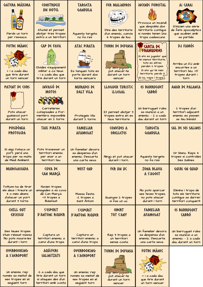
Once the map is drawn, it’s time to define the bonuses and special rules. By creating a custom map, you can define your own bonuses to incentivize players to conquer certain areas, adding an extra layer of strategy to the game. You can also introduce special rules or cards adapted to the theme. In my case, the card set shows the territory on one side and, on the other, special rules inspired by popular culture, with a touch of local humor.
6. Play and Adjust
After creating the map, it is fundamental to test it by playing several matches. This will allow you to identify any imbalances in the distribution of territories, connections, or bonuses. Based on these tests, you can make adjustments to improve the gameplay and the balance of the map.

I hope you enjoyed this article. I encourage you to download the designs for Risc: Eivissa i Formentera or create your own custom map and share your experience in the comments. Good luck and enjoy conquering the world!